• Welcome to https://albinowners.net, the new home of Albin Owners Group!
• You will need to log in here, and you may want to bookmark this site. If you don't remember your password, use the I forgot my password link to reset it.
• All content has been transferred from our previous site. Digests will be enabled soon.
• Contact Us if you have any questions or notice a problem. If you're not receiving our email, include a phone number where we can text you.
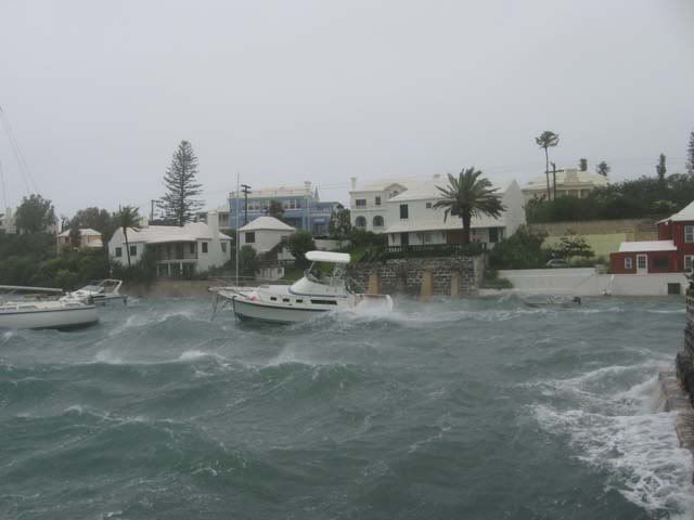
On October 18th, we were hit with an unusual mid-day windstorm as a strong low pressure front moved in from the southwest. In the span of about an hour, winds surged from nearly zero knots to over 40. Gusts flirted with 50 knots. The storm lasted only a couple hours. Usually these storms come in during the evening and overnight hours, and they usually hit much later in the season (January and February). The storm was expected, but it was so calm before the storm actually hit, that most people dismissed the warnings, thinking it had missed us and passed to the north. Some of you may recall my post about a guy in a rowing shell heading out for open water. Early in the day, the water was so calm, that he could have done so safely. But by early afternoon, THIS is what it looked like on Puget Sound:
And as you look at the picture, keep in mind that the location where these were taken is about 100 miles inland behind the Olympic Mountain range. And given the direction the winds were coming from, they passed over aproximately 130 miles of land before this, losing much of their energy. The fetch at his loation is about 15 miles.
The situation is made somewhat more spectacular than it really is due to the construction of the ferries. Due to the high number of runs the Washington State Ferries make every day, they are designed to be, above all things, efficient. You will notice that, despite considerable above deck space, the hull is actually rather slender and narrow. Due to the fact that ferries, by definition, cross waterways, they are frequently exposed to beam seas. That is the case here. This vessel is heeling from side to side primarily becuase it has a slender and shallow hull below the waterline and is in a beam sea. The spray and green water washing onto the car deck is caused by the fact that they have a low, flat bow.
WSF boats are not the most seaworthy for their size, but the truth is that they don't usually face conditions like this, and when they do, it's usually at night when the boats are not heavily loaded, if they're even running at all.
These maps might give you a better idea of where the wind was coming from. It ran up from the SW, avoiding the mountains and whipping in thorugh the various river plateaus that make up SW Washington, and then up the Puget Sound basin. The second picture shows the fetch and orientation of the ferry's route.
Isn't this basically the same wind condition that caused the Tacoma Narrows Bridge to go into aerodynamic resonance and collapse in 1940? (See http://en.wikipedia.org/wiki/Tacoma_Narrows_Bridge which has the dramatic footage of the collapse). The bridge was nicknamed Galloping Gertie. I saw the film of the collapse the first time when I was in engineering school in the 60s studying aerodynamics. It is a classic.
Yes. These are actually the prevailing winds here. The only thing that made this any different from normal was that they don't normally get this strong, this early in the season. The winds that brought down the first bridge weren't all that strong even. Not as strong as what you see in these pictures.
I drive over the new bridges almost every day. The second bridge was built in 1950, and the third bridge, built parallel to the '50 bridge was just completed this July.
For Elizabeth Ann,
The photos came out of order. The first two were actually taken last. Eastbound courses used on this route as referenced on chart 18443 normally begin at the Clinton, Whidbey Island slip with a heading 138 true, turn easterly at mid-channel after running 1.27 nm to heading 120 true and finish 1.15 nm further on at the Mukilteo slip. Per Note C, "Mariners are cautioned that the Washington State Ferries may deviate from the published standard routes due to inclement weather, traffic conditions, navigational hazards or other emergency conditions."
In these photos it appears the westbound boat was re-routed to the southwest because he's visible heading northwesterly toward the Clinton landing behind m/v Cathlamet. This routing allowed the westbound boat to meet the seas at a more favorable angle for a shorter period than if the normal westbound legs were taken, and also gives a nice long approach in more sheltered water than the normal routing would.
As for m/v Cathlamet's final turn into the approach to Mukilteo, it might have been taken late in this case to allow a more favorable angle of attack during the eastbound legs but the effect of wind and wave shown in the first two photos is entirely unavoidable because the turn must be executed fully exposed in open waters to allow a sufficiently long approach to the slip. Alongshore currents are also a serious factor at this particular landing but there's no way to assess their effects from these photos.
(former owners)
Joe Baar and Suzanne Lammers
1995 28TE "Liberty" 6LPA hull# 132
Ballard
Mariner:
Your photos are excellent. They made me happy that I was at home in front of the computer monitor. I may have missed it, but was there any mention of where you were when these pictures were taken? My assumption is that you were out fishing or just out for a spin aboard your Albin. Am I assuming too much?
Fairtide
Those pictures are great, thanks for sending them in. But I would almost bet that a smaller well constructed boat, (like an Albin) would ride out waves like that better than the larger heavier ferry, but I could be all wet there.
The pictures are not mine. I wan't to clear that up. They were widely circulated around the net and there was even some controversey regarding their origination. Several people have claimed them, though one seems to have emerged as the legitimate photographer.
As for how a boat would fare in that weather, the reason the ferries fared so poorly (their integrity was preserved, but a lot of cars got damaged), is due to their top-heavy design and unprotected bow. They are designed for efficient and fast service on relatively calm water (for vessels of their size). While ocean going ferries have to contend with ocean swells, even in relatively mild climates, the WSF vessels do not. The chop can be brutal on Puget Sound, but rarely to real swells develop. Thus, the boats can be designed with relatively low freeboard, and a very sleek and narrow hull. The idea is that, when the weather kicks up, they are simply taken out of service until the storm passes. This storm, however, kicked up record wind speeds in record time. The NDBC archive information isn't detailed enough to show it, but I tracked the winds as they climbed that day. In less than about 15 minutes, winds went from flat calm to 60+. Considering that the Mukilteo-Clinton ferry run is probably about 30 minutes, that didn't give the crew much time to prepare.
How would an Albin fare? Skillfully captained? Probably just fine. But it's easy to get into trouble very quickly in that kind of weather.
By the way, that storm in October pales in comparison to what we experienced on the coast last week. The winds didn't make it into the Puget Sound basin, due to a more westerly track, but they wreaked all kinds of havoc out on the coast. The damage is still being assessed and many are still without power.